Mengenai Saya

Foto saya
Just a teenager who is finding an identity. Need help, spirit, care and love from anyone around.
Diberdayakan oleh Blogger.

Mount Rinjani

0
Mount Rinjani & Segara Anak Crater Lake
Standing at a majestic 3726 m, Mt. Rinjani located in the North of Lombok, is the second highest peak in Indonesia. For the people of Lombok, Sasak and Balinese alike, this mountain is a sacred place where, at the summit, the holy gods live.

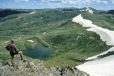
A large crater lake Segara Anak, located at 2000 m above sea level is the destination of many pilgrims, who make the annual trek up the steep slopes in order to place offerings to the gods in the lake itself. Within this breathtaking crater lake has appeared a new and active volcano, Mt. Barujari. On the north side of the lake is a hot spring (one of 4 Segara Anak hot springs found there) which is said to cure disease.

To climb such an impressive mountain is an unforgettable experience. Starting points for such a trek can begin at Senaru in the North (or from Sembalun from the east) ‑ this two or three day trek attacks Rinjani from the West with a descent to the awesome crater lake before again climbing up and out and on to the summit.

A model for ecotourism in Indonesia, the community-based activities are focused on the Rinjani Trek Centre in Senaru, the most popular starting point for the tough trek. Developed with New Zealand Government assistance since 1999, the Rinjani Trek Centre embodies under one roof (satu atap) the unique partnership of the National Park, tourism industry and local communities that has been forged to manage and protect the Rinjani mountain environment.
 
Rinjani volcano towers over the beautiful island of Lombok in West Nusa Tenggara province. Rising from the sparkling rice terraces to a dizzying height of 3,726 meters, it is the second-highest volcanic peak in Indonesia.
Only Gunung Kerinci in Sumatra is higher, at 3805 metres. Unlike the smooth cones of Bali and Java, Rinjani is more a massif than a single peak: the huge crater is some six kilometres across, and shelters a deep lake.

Rinjani volcano on the island of Lombok rises to 3726 m, second in height among Indonesian volcanoes only to Sumatra's Kerinci volcano. Rinjani has a steep-sided conical profile when viewed from the east, but the west side of the compound volcano is truncated by the 6 x 8.5 km, oval-shaped Segara Anak caldera. The western half of the caldera contains a 230-m-deep lake whose crescentic form results from growth of the post-caldera cone Barujari at the east end of the caldera. Historical eruptions at Rinjani dating back to 1847 have been restricted to Barujari cone and consist of moderate explosive activity and occasional lava flows that have entered Segara Anak lake.

The whole of the Rinjani area was gazetted as a national park in 1997, and the mountain is one of the most prized trekking destinations in Southeast Asia.
Rinjani is located in a caldera 2.4 km by 4.8 km in size. There are two active centres located in the eastern part of caldera - Barujari and Rombongan cones.  Segara Anak Lake is situated inside the caldera.

On 3 November 1994, a cold lahar from the summit area of Rinjani Volcano traveled down the Kokok Jenggak River.

Thirty people from the village of Aikmel who were collecting water from the river were killed.

Eruptions of Rinjani Volcano
2004, 1994, 1966, 1965, 1953, 1949-50, 1944-45, 1941?, 1915, 1909, 1906, 1901, 1900, 1884, 1847

Getting There
We can manage the transport to Senaru or Sembalun Lawang. These two village can be reached by private and charter vehicle, or by public bus. Form the west, catch a bemo to Anyar, from where bemos travel to Senaru about every 20 minutes until 4 pm. If you are coming from, or going to, eastern Lombok, get off at the junction near Bayan (your driver will know it), from where bemos go to Senaru. To Sembalun Lawang and Sembalun Bumbun, from Kali Putih to the north, a few bemos run along the rough road to both villages, usually only in the morning.

Segara Anak Lake
Segara Anak Lake is so wide it appears like the sea with its blue water. The name Segara Anak means child of the sea. Segara Anak Lake holds various mysteries and invisible power.

Eternal Flower or Edelweis
The plant or the flowers should not be taken because it grows in the park and in the mysterious world of the spirit kingdom. In the past, someone who wanted this flower must be brave enough to fight and gamble his soul. That is why the flower is called Sandar Nyawa. The flower has never wilted and is as old as the mysterious spirits.

The Peak of Rinjani
The people of Lombok believe that the peak of Mt. Rinjani is where Dewi Anjani, the queen spirit and ruler of Mt. Rinjani lives. To the south-east from the peak in a sea of dust called Segara Muncar is the invisible palace of the queen Dewi Anjani and her followers.

Mount Baru Jari
Gunung Baru is the name of the new volcano which emerged in the center of Segara Anak Lake. People believe that Gunung Baru is the navel of Mt. Rinjani. That is why if Gunung Baru erupted it will not harm the people of Lombok unless the eruption is from the peak of Mt. Rinjani.


Other Things to See or Do
Beside the mountain itself, other things for you to do or see is:
1.       Caves
One of the three famous caves (Goa Susu, Goa Payung, dan Goa Manik), Susu Cave is a good place for self reflection and is often used as a place to meditate.

2.       Healing Hot Springs
Aiq Kalak means hot water and it is used to cure various deseases. One of the hot springs is named Pangkereman Jembangan which is meant a place for dipping. The water which spurts out of the spring is very hot. People also use the hot spring to make medicine from coconut cream. After dipping a bottle of coconut cream in the hot spring if the liquid becomes clear oily it can be used as medicinal oil. Then the medicinal oil is used for good things and is called Siu Satus Tunggal or in Bayan language Siu Satunggal which means that it can be used to cure a thousand kinds of disease.

3.       Segara Anak Lake
Segara Anak Lake is so wide it appears like the sea with its blue water. The name Segara Anak means child of the sea. Segara Anak Lake holds various mysteries and invisible power.

4.       Local Strawberry
This plant grows along the route to Mt. Rinjani. It has thorns like the rose and the fruit is red like strawberry. It has a sweet and slightly sour taste and is good to eat when trekkers are hungry and thirsty.

5.       Eternal Flower or Edelweis
The plant or the flowers should not be taken because it grows in the park and in the mysterious world of the spirit kingdom. In the past, someone who wanted this flower must be brave enough to fight and gamble his soul. That is why the flower is called Sandar Nyawa. The flower has never wilted and is as old as the mysterious spirits.

6.       The Peak of Rinjani
The people of Lombok believe that the peak of Mt. Rinjani is where Dewi Anjani, the queen spirit and ruler of Mt. Rinjani lives. To the south-east from the peak in a sea of dust called Segara Muncar is the invisible palace of the queen Dewi Anjani and her followers.

7.       Mount Baru Jari
Gunung Baru is the name of the new volcano which emerged in the center of Segara Anak Lake. People believe that Gunung Baru is the navel of Mt. Rinjani. That is why if Gunung Baru erupted it will not harm the people of Lombok unless the eruption is from the peak of Mt. Rinjani.

Read more

Mount Semeru (Mahameru)

0
Mount Semeru or Sumeru is the highest volcano on Java island, with a peak Mahameru, 3676 meters above sea level (mdpl). The crater at the peak of Mount Semeru Jonggring known Saloko.

Semeru has dipterokarp forest hills, forest above dipterokarp, Montane forest, and ericaceous forests or mountain forests.

The position of this mountain region located between the administration and Lumajang Malang Regency, with a geographic position between 8 ° 06 'S and 120 ° 55' E.


In the year 1913 and 1946 crater dome Jonggring Saloka has a height of 3744.8 M until the end of November 1973. Adjacent to the south, the dome crater edge to break the flow of lava gets Pasirian southern regions, and Lumajang Candiputro.

Travel
It takes about four days to climb the mountain Sumeru round-trip. To climb the mountain semeru can be done through the city of Malang or Lumajang. From the terminal we poor city ride public transportation to the village Mixed. Connected again with the jeep or truck there is lots of vegetables in the back of the terminal market with cost Tumpang 20,000 per person, - to post Ranu Pane.


Previously we stopped at Gubugklakah to obtain a driver's license, with the details, license fees Rp.6.000, - to a maximum of 10 people, park admission Rp.2.000, - per person, per person Rp.2.000 Insurance.


By using vegetable truck or jeep trip starts from Mixed to Ranu Pani, the last village at the foot semeru. Here is the post examination, there are also shops and cottages. For climbers who brought the tent is charged Rp 20,000, -/tenda and if a camera is charged Rp 5,000, -/buah. Climbers can also spend the night at the guard post. Ranu Pani in the post, there are two lakes namely Lake Ranu Pane (1 ha) and Lake Ranu Regulo (0.75 ha). Situated at an altitude of 2200 mdpl.

Having arrived at the gate "welcome", note continues to the left up the hill, do not follow the broad road to the garden population. In addition to the usual path traveled the climbers, there is also a common shortcut used by local climbers, this path is very steep.


After walking about 5 km down the hillside overgrown with flowers Edelweis lot, and will arrive at Watu Rejeng. Here there is a steep stone is very beautiful. Very beautiful scenery to the valley and hills, are overgrown with fir and pine forests. Sometimes the smoke can be seen from the top of semeru. Ranu Kumbolo to go still has a distance of about 4.5 Km.


In Ranu Kumbolo be setting up camp. There is also a climbing hut (shelter). There is a lake with clean water and has beautiful scenery, especially in the morning to watch the sunrise on the sidelines of hill. Many fish, sometimes wild grouse. Ranu Kumbolo an altitude of 2400 m with an area of 14 ha.


Of Ranu Kumbolo should prepare as much water as possible. Ranu Kumbolo left then climb the steep hill, with beautiful scenery at the lake behind. In front of the hill lies a vast prairie called oro-oro Ombo. Oro-oro Ombo surrounded by hills and mountains with beautiful scenery, wide meadows with slopes of pine trees like in Europe. From behind the Mt. Kepolo looked peak Mt. Semeru Gembel wedus smoke belching.

Further into the Pine forests where the birds and sometimes deer are found, sometimes a tiger, which he said had become extinct Java tiger. This area is called Cemoro Cage.

Postal Kalimati an altitude of 2700 m, here, can be set up tents for a rest. This postal area of pasture on the edge of pine forest, so many available branches to build a fire.


There SumberMani springs, to the west (right) through the edge of the forest with a distance Kalimati 1 hour round trip. In Kalimati and in many Arcopodo mountain rats.


For to Arcopodo turn left (East) runs about 500 meters, then turn right (south) down a little Kalimati pasture. Arcopodo is 1 hour from Kalimati through pine forests very steep, with a simple soil erosion and dust. We can also camped in Arcopodo, but less stable soil conditions and frequent landslides. We recommend using goggles and masks because many fly ash. Arcopodo an altitude of 2.900m, is the area of vegetation Arcopodo last at Mount Semeru, the rest will be through the sand dunes.


To the top of Semeru Arcopodo takes 3-4 hours, past the dunes very steep and easily dropped. As a travel guide, at this point there are several small triangular flag is red. All luggage should stay in or on Kalimati Arcopodo. The climb to the summit made the early morning at around 02.00 am from Arcopodo.


Daytime wind cendurung north toward the summit carrying a toxic gas from the crater Jonggring Saloka.

The climb should be done in the dry season is in June, July, August, and September. Should not climb in the rainy season due to frequent storms and landslides.

Poison Gas
At the peak of Mount Semeru (top Mahameru) climbers are advised to not to Jonggring Saloko crater, also prohibited from ascending the south side, because of the poisonous gas and lava flows. Mahameru dipuncak temperature ranges from 4 to 10 degrees Celsius, at the peak of the dry season minus 0 degrees Celsius, and found ice crystals. The weather is often foggy, especially at lunch, afternoon and evening. The wind, the month of December to January is often a storm.

Gembel wedus eruption every 15-30 minutes at the peak of Sumeru mountain is still active. In November 1997 Gn.Semeru erupted 2990 times as much. At noon the wind to the summit, to avoid it came in the afternoon peak, because the poisonous gas and the explosion led to the summit.

The eruption of white smoke, gray to black with the eruption of 300-800 meters high. Material that came out on every eruption of ash, sand, gravel, stones and even hot burning very dangerous if the climber is too close. In early 1994 the hot lava streaming down the southern slope Gn.Semeru and asked several casualties, hot river scenery, winding toward the sea has become a very interesting spectacle.


Climate
In general, the climate in the region including the Sumeru mountain climate type B (schmit and Ferguson) with 927 mm rainfall - 5498 mm per year with the number of rainy days 136 days / year and the rainy season falls in the month of November to April. Semeru dipuncak Temperatures range from 0 to 4 degrees Celsius.


The average temperature ranges between 3 °C - 8 °C at night and early morning, whereas during the day ranged between 15 °C - 21 °C. Sometimes in some areas there is little snowfall occurs during the rainy season changes to summer or vice versa. Cold temperatures along this route is not only caused by the air still but is supported by the wind that blew into the area causing the cold air.

National Parks

The mountain is entered in the National Park area Bromo Tengger Semeru. This National Park consists of mountains and valleys covering 50,273.3 hectares. There are several mountains in the Caldera Gn.Tengger among others; Gn.Bromo (2.392m) Mt. Batok (2.470m) Gn.Kursi (2.581 m) Gn.Watangan (2.662m) Gn.Widodaren (2.650m). There are four lakes (ranu): Ranu Pani, Ranu Regulo, Ranu Kumbolo, Ranu Darungan.

Flora in the Region of Mount Semeru diverse species but many dominated by pine, acacia, pine, and the type of lamuju. As for the plants dominated by kirinyuh, reeds, tembelekan, harendong and white Edelwiss, there is lots of Edelwiss on the slopes toward the Sumeru Peak. And also found several species of orchids endemic to living in the surrounding South Semeru.


Many of fauna which inhabit the mountain Sumeru, among others: Tiger beetles, Budeng, Luwak, deer, deer, etc.. While in there Kumbolo Ranu Belibis wild living.


The First Climber

The first person to climb this mountain is Clignet (1838) was a Dutch geologist from the southwest through Widodaren, then Junhuhn (1945) was a Dutch botanist from the north through the mountains Ayet-ayek, mountain-Inder and Inder Kepolo mountain. In 1911 Van Gogh and Heim through the northern slopes and after 1945 are generally carried out by climbing through the northern slopes and Ranu Kumbolo Ranupane today.

Legend of Mount Semeru
According to Javanese belief written in ancient books that come Tantu Cultural dariabad to 15, the island of Java at some time floating in the ocean, the waves being played here and there. The Gods decided to tack the island of Java in a way to move Mount Meru in India to the island of Java.

Lord Vishnu transformed into a giant turtle holding dipunggungnya mountain, while Lord Brahma was transformed into a long snake that wraps her body in the mountains and the tortoise, so the mountain can be transported safely.


The Gods are placed on top of the mountain the first part of the island they met, namely in the western part of Java Island. But the weight of the mountain caused the eastern tip of the island rose into the air. Then they move to the east of the island but still crooked, so they decided to cut some of the mountain and placed in the northwest.


This fragment formed Pawitra Mountain, which is now known as Mount Pananggungan, and the main part of Mount Meru, where dwells the god Shiva, is now known as Mount Sumeru. At the time of Sang Hyang Shiva came to the island of Java barley saw many trees, so the island is called Java.


Geographical environment of Java and Bali were matched with symbols of the Hindu religion. In the Hindu religion is the belief of Mount Meru, Mount Meru is considered as the home of the gods and as a means of liaison between the earth (man) and Heaven. If people want to hear the voices of their gods to meditation at the top of Mount Meru. Many Javanese and Balinese society today still consider the mountain as the dwelling place of gods or spirits. Furthermore mountainous areas are still used by people of Java as a place of meditation to hear the magic.


According to the Balinese Mount Mahameru believed to be the father of Mount Agung in Bali and respected by the people of Bali. Ceremonial offerings to the gods of Mount Mahameru done by the Balinese. However ceremony conducted only once every 8-12 years at the time people just accept the mysterious voice from the gods of Mount Mahameru. Besides offering ceremony of the Balinese that often come to the cave to get Tirta Widodaren sacred.

People rose to the top there Mahameru which aims to hear the magical sounds. There was also a request to be given a prolonged life. However the reason people climbed to the top Mahameru, most people feared by the various ghosts that inhabit the area around the mountain. These ghosts are the spirits of ancestors who inhabit places like forests, hills, trees and lakes.


Ancestral spirits are usually aimed at keeping the various places and must be respected. Hikers who stay at the lake Kumbolo Ranu Ranu often see ghosts Kumbolo. At midnight there was light orange in the middle of the lake and suddenly transformed into a ghost woman. Usually only people who have mystical powers he will see ghosts and can talk to ghosts. Whatever people believe in ghosts or not but many people who believe that the Java area Bromo, Tengger, Semeru many inhabited by ghosts.
Read more

Mount Kosciuszko

0
Elevation: 7,310 feet (2,228 meters)

Location: Great Dividing Range, New South Wales, Australia.

First Ascent: First ascent by an expedition led by Polish explorer Count Pawel Edmund Strzelecki, 1840

The Summit
Mount Kosciuszko is Australia’s highest peak standing at 2228 metres above sea level. The Europeans were the first to scale the mountain, with Polish explorer Paul Edmund Strzelecki naming the peak after its similarity to the tomb of the Polish patriot Kosciuszko. A plaque on the summit commemorates his early achievements. The aboriginal name for the mountain is Tar Gan Gil.

Mount Kosciuszko is located in the southern section of the Kosciuszko National Park, latitude -36º 27' 26", longitude 148º 15' 44". The closest access point to Mount Kosciuszko is from the top of the Kosciuszko Express Chairlift in Thredbo. The relevant 1:50,000 topographical map is 'Mount Kosciusko 8525 - 11 & 111" and adjoining map 'Thredbo 8524 - N'.

Mount Kosciuszko is only slightly higher than the other major peaks: Townsend, Carruthers, and Twynam that form the spine of the spectacular Main Range, backdrop to mainland Australia's only glacial lakes. On your journey to the roof top of Australia you’ll cross the spectacular head waters of the Snowy River, discover the amazing and truly unique flora and fauna, and be taken away by the magnificent 360 degree views at the summit. The view takes in the Victorian High Country, the Main Range & the Monaro tablelands.

Official exploration of the mountains came with the detailed surveys of Thomas Townsend in 1846-7. Clement Wragge, of Queensland, established a meteorological station on the summit in 1898 and this was manned and operated for several years. Later still, under the administration of NSW Premier, Sir Joseph Carruthers, the 50-kilometre road from Jindabyne to the summit, The Creel at Thredbo and the Hotel Kosciusko were completed in 1909. The latter famous resort was destroyed by fire in 1951.

During the last ice age, glaciers tore at the granite of the Main Range, leaving lakes and huge boulders in their wake as they slowly moved across the landscape. Miniature replays of this action occur each summer as the compacted snow drifts from the winter collapse in slabs upon the waters of the Lakes known as Blue, Albina, Club, Cootapatamba & Headly Tarn.

There are no refreshments available along the track so be sure and take a picnic lunch and at least 1 litre of water per person. There are toilets at Rawson Pass. The return distance from the top of the Kosciuszko Express Chairlift is 13kms and the trip takes about 5 hours.

Kosciuszko National Park
The Kosciuszko National Park is Australia’s highest national park, covering 1.5 million acres of magnificent alpine terrain. The Park is host to a wonderful variety of flora and fauna, including many alpine plants, which are found nowhere else in the world. More than 200 species of birds have been sighted in the Park - almost 40 percent of the known bird species in NSW. The awesome wedge-tailed eagle is a common sight as are kestrels, emus, cockatoos and magpies.

The Parks outstanding natural features received international recognition in 1977 when it was made a UNESCO Biosphere Reserve.

Camping is permitted virtually anywhere in the Park except:
1. in the catchment areas of the glacial lakes 
2. in the resort areas 
3. at Yarrangobilly Caves

Basic facilities such as pit toilets and fireplaces are provided in the picnic /camping areas. Elsewhere camps should be out of sight of the roads and well away from water courses. Mountain biking is permitted on all fire and maintenance trails within the Park.

Park use fees are payable when entering the Park on the Kosciuszko Alpine Way from Jindabyne or Khancoban.

The Kosciuszko Alpine Way
This is one of Australia's greatest scenic drives, winding through the magnificent Kosciuszko National Park. You’ll pass by snow capped peaks, fields ablaze with wildflowers and deep blue lakes teaming with trout. The diverse array of wildlife is sure to keep you enthralled.

The Southern Section
When leaving Albury the route crosses the Hume Weir and then heads towards the quaint town of Walwa, nestled on the banks of the Murray River. The route follows the Murray and affords magnificent views of the western faces of the Snowy Mountains.
Begin to discover what Australia's High Country really means. Just before Corryong the route turns off to Khancoban and Thredbo. Khancoban was built as a construction town for the Snowy Mountains Hydro-electric Scheme.

The Scheme is one of the great feats of world engineering with massive pipes, power stations, and information centres dotted along the route. The displays at the Murray One power station, near Khancoban, give an overview of the Scheme.

There are all types of accommodation along the route, from camping facilities to guest houses, farm stays, historic hotels to 5 star resorts.

Khancoban - Thredbo – Jindabyne
This stretch is filled with magnificent alpine vistas and pristine picnic spots. In summer you can explore the Snowy trails by horse or on foot. Wet a line and tackle the rainbow and brown trout in the sparkling lakes and streams. The adrenalin junkies can have a crack at white water rafting or hammer downhill on a mountain bike.

In winter snow riding action takes the slopes by storm, with something for first timers right through to the hard core mountain machines.

Thredbo provides the most convenient access point to Mt Kosciuszko, Australia's highest mountain at 2228m above sea level. The walk to the summit of Mt Kosciuszko is easy, particularly if you take the chairlift up the Ramshead Range from Thredbo.

The Snowy Mountains boasts Australia's highest golf course, tennis courts, guided walks, mountain bike hire and tuition, fly fishing, abseiling, music and adventure festivals, and much, much more.
Situated on Lake Jindabyne, the town of Jindabyne is home to the Snowy Region Visitor Centre and two modern shopping centres, offering everything from supermarkets to specialty shops.

The Northern Section
The northern section of the route travels through the Monaro Plains, Cooma and then on to Canberra, Queanbeyan and Goulburn. Cooma, known locally as the capital of the Snowy Mountains, is the retail and business centre of the region.

Visit villages, historic huts and homesteads dating from days when the first Europeans drove their stock across the Monaro Plains, and wander around the National Trust listed streets.
The route includes Australia's national capital, Canberra. Experience the history and culture of Parliament House, the National Library, the National Gallery, the High Court and the Australian War Memorial.

Take the alternative scenic route and enjoy the Snowy Mountains - Australia's High Country.

Read more
 
Copyright 2009 The Backpacker Kebonan
Design by BloggerThemes
Search Engine Submission - AddMe